 |
111. The Castle
at the End of the Street
Sometimes, I stop to read the blue plaques, the
historical markers that pop up throughout Cardiff.
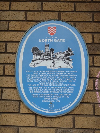
The blue plaque on the corner of Northgate House
perturbed me. It told of the wall that once enclosed
the medieval town of Cardiff, and that I was
standing where once existed the North Gate. It told
much more that I would have to piece together later
with internet research. When I had first read this
blue plaque long ago, the words I particularly noted
were, “The last of the wall stands close to this
place.” I had spun around and there was no such wall
obvious. But wait, there was inexplicable stonework
across the wide street, Kingsway, close to the
towering wall of Cardiff Castle. A mound of earth
climbs against the back of that short piece of wall
and serves as one of the city’s many flowerbeds.
There was more to it.
It was my turn to serve as quizmeister at the weekly
Zoom get-together with friends. Since the pandemic
has temporarily closed the pub where we battled
every Quiz Night, our team has been playing amongst
ourselves. Two weeks ago, I began researching via
the internet for clever questions to pose to my
fellow Cardiffians. The plan was to present them
with photographs from around City Centre and see if
they could identify the object’s significance and
location. It was while searching the internet that I
discovered the flowerbed by the castle was not the
last of the wall referred to by the North Gate blue
plaque.
Returning to the North Gate blue plaque, going down
an unnamed alley between Northgate House (student
housing) and 2 Kingsway (office building), there was
the wall referenced by the plaque. It is behind
Northgate House and is not visible when standing in
front of the plaque.
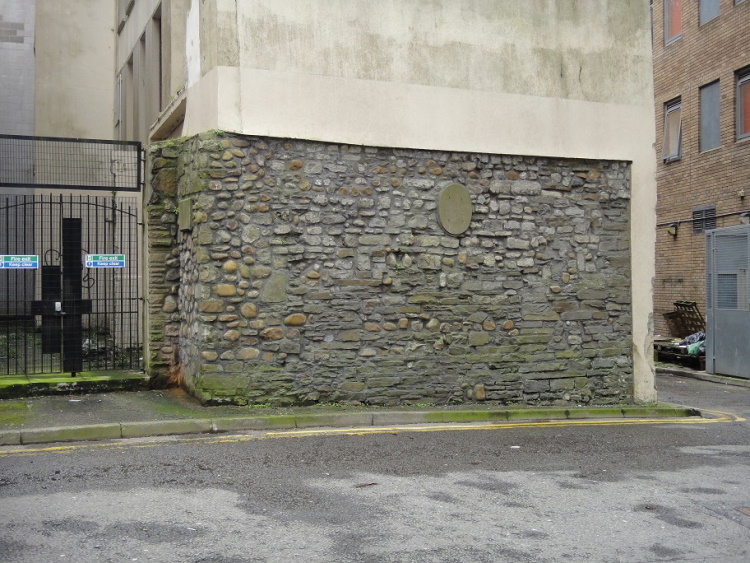
This piece of wall is nearly ten feet high and
twenty feet long. If you stand far enough away and
to the side to see both this wall behind Northgate
House and the flowerbed wall near the castle, you
can tell they line up and were possibly once joined.
Photographing the wall, I presented the image to the
quizzers. One guessed correctly as to what it might
be, but none of them could tell me where it was.
The quiz is over for this week. Someone else is
quizmeister this coming Wednesday. However, my
curiosity had been piqued. I learned from my
research that the wall enclosing Cardiff was just
over a mile and a quarter in circumference. It was
as much as eight feet thick in places and ten feet
high. I decided to trace the path of the ancient
wall. A mile and a quarter was a comfortable stroll
and maybe I would find the other four gates or, at
least, their blue plaques.
To support my exploration, I printed several old
maps found on the internet, primarily a copy of
cartographer John Speed’s 1610 map of Cardiff. Off I
went the very next Sunday, exploring.
It was a typical Cardiff afternoon, overcast and
threatening to rain. I returned to that piece of the
north wall and, from there, would begin my clockwise
circumnavigation of the old town of Cardiff. On the
wall was an empty escutcheon from which had been
stolen a blue plaque. It probably announced this
wall being part of the North Gate, which had been
destroyed in 1781.
I left the misshapen alley at its east end and
turned right on The Friary. Here the wall turned
south. Here, too, was the Glamorganshire Canal
entombed beneath The Friary. The 25-mile-long canal
brought iron down from Merthyr Tydfil to the docks
of Cardiff. It had followed the North Road along
Bute Park, then shifted to skirt the east wall,
serving as a moat as it bypassed the town. Built in
1792, the last barge to travel it was as recent as
1942.
For one block, I gave way to imagining drifting into
town, no bumps, no ruts, a still feeling with
buildings floating past. The block ended at Queen
Street and here was another blue plaque.
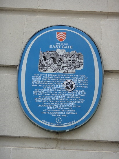
This was Cardiff’s East Gate, unexpectedly
close to the North Gate. The East Gate was also
destroyed in 1781. The blue plaque tells the reader
that, "In the 18th century with the building of the
Glamorganshire Canal, Crockherbtown Lock stood by
the site of the Old Gate." What it doesn’t reveal is
that the lock lowered the canal boats to pass
through a tunnel under what is now Queen Street. The
tunnel burrowed 115 yards. Being too narrow for a
towpath, the horses were led through the city to
greet the boats where they came out. To move the
boats beneath the streets, the boatmen pulled
themselves along by a chain fixed to the tunnel’s
wall. I wondered if the underground canal was
represented by the lower level of the Queen’s
Arcade.
The Queen’s Arcade is closed to shoppers because of
the pandemic. I could not trace either the city’s
wall or canal beyond this point and so decided to be
like the horses and pick it up further south.
To get there, I walked around the sealed shopping
center. At the old library, a grand building of
carved stones that rises from the center of The
Hayes, there is the first entrance to the Saint
David’s Shopping Centre. Also closed because of the
lockdown, yet I knew from an earlier experience,
that just a few yards inside, inlaid into the tile
floor, they had marked where the town’s wall once
stood. It was discovering those markings soon after
arriving to Cardiff that I first learned of the
wall’s existence.
I bypassed the Saint David’s Shopping Centre (11th
largest, 3rd busiest in the UK) and came to the
bottom of The Hayes. This is where the new library
sits, a glass box with sloping roof on which grass
grows. Mill Lane begins here and proceeds at the
same angle as did the wall and later the canal. In
fact, Mill Lane was a portion of the canal. Mill
Lane ends in Saint Mary Street.
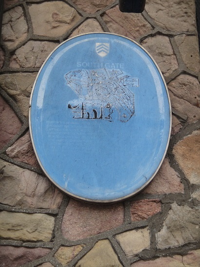
There it was, across Saint Mary Street, another blue
plaque attached to the Great Western Hotel, now a
Wetherspoon pub. The building is a beautiful stone
edifice, built in 1875, that bends around the
corner. The blue plaque, in correlation with Speed’s
map, revealed that I had found the South Gate, the
third gate. Except for its title, the blue plaque
was no longer legible. The South Gate was destroyed
in 1802.
From here, I turned north on Saint Mary Street,
named for the Saint Mary Church that once stood
nearby. The River Taff also once flowed near the
church. Too near. In 1607, the church was devastated
by flood waters rising out of the Bristol Channel.
The damage undermined the foundations of the church
and it had to be abandoned. In its place is the
Prince of Wales pub, formerly a theater.
The Prince of Wales is one block west of Saint Mary
Street. Westgate Street starts from the Prince. I
walked north on Westgate Street because, before the
River Taff was moved, Westgate Street was the river.
Cardiff didn’t need a west wall, it was guarded by
the River Taff.
The river had been diverted in 1853. At the corner
of Westgate Street and Quay Street there is another
blue plaque to be found. The very name, “Quay”
Street gives away its origins. Here were docks that
supported very large ships of the time. I stood
awhile at the end of Quay Street envisioning the
asphalt of Westgate a flowing river. I put
three-mast ships on it. I became the sailor stepping
off the gangplank and gazing down Quay Street, which
becomes Church Street a block later, and you can see
the tower of Saint John the Baptist Church, as you
could then, greeting new arrivals.
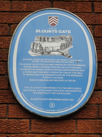
The blue plaque said I was standing at Blounts Gate,
the fourth gate. The gate was destroyed in 1786. The
plaque informed me, “Evidence of Roman habitation
[75AD] was uncovered in 1974.” It also informed me,
“A stone quay was built c1263 & the line of the
wall is marked on the ground floor of the Westgate
Street Car Park.” I searched, but there was no way
into the NCP car park. All its doors and gates were
locked.
I continued north until I reached the castle at the
end of the street. The West Gate was destroyed in
1781. However, adjacent to the castle is a replica
of the West Gate that John Crichton-Stuart, 4th
Marquess of Bute, had built in 1921 on the original
foundations.
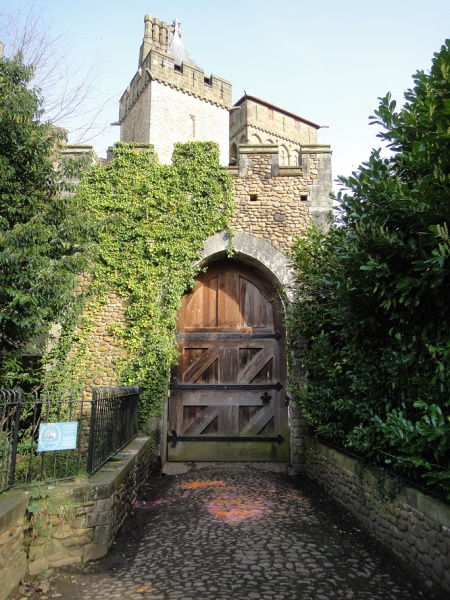
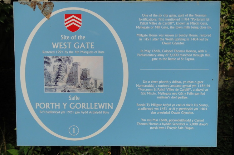
It is not to be confused with the West Lodge Gate, where you will find the charming Pettigrew Tea Rooms. You cannot reach the West Gate from Castle Street. West Street is a dead end blocked by a wrought iron gate. The area is used by the staff for parking. You can see through the grating to the West Gate at the far end. But you can also enter Bute Park through the West Lodge Gate and work your way over to the outside of the West Gate and there will be a blue plaque, the fifth and last gate of my exploration.
I concluded the circumnavigation of medieval
Cardiff, passing behind Cardiff Castle to the
remaining piece of wall where I began. The first
town wall was made of wood in 1111. I am not sure
when the wall was converted to stone. The first
stone wall was destroyed when Owain Glyndŵr, the
last Welsh Prince of Wales, sacked Cardiff in 1404.
It was rebuilt. I spent a fine afternoon trying to
model that earlier place in my mind.
My flat is smack in the middle of that medieval
town. Born over 3,000 miles away and 70 years ago in
the Bronx, New York City, never was I expecting to
find myself living where there would be a castle at
the end of the street.
![]()
Mr Bentzman will continue to report here regularly about
the events and concerns of his life. If you've any
comments or suggestions, he would be pleased to hear from you.
You can find his
several books at www.Bentzman.com.
Enshrined
Inside Me, his second collection of
essays, is now available to purchase.